
São Sebastião topographic map
Click on the map to display elevation.
About this map
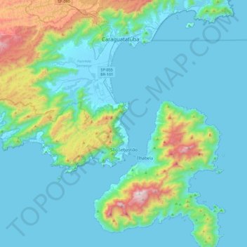
Name: São Sebastião topographic map, elevation, terrain.
Average elevation: 202 m
Minimum elevation: -4 m
Maximum elevation: 1,328 m
Other topographic maps
Click on a map to view its topography, its elevation and its terrain.
Serra da Mantiqueira
Brazil > São Paulo > Região Metropolitana do Vale do Paraíba e Litoral Norte > Queluz
The Serra da Mantiqueira is a part of the Atlantic Forest ecosystem. Despite the clearing of the land for livestock raising, the difficult access to many areas has made possible for sanctuaries of well-preserved forest to still exist, with trees such as the jacarandá, Spanish cedar, canjerana, guatambu, ipê,…
Average elevation: 2,271 m