Geolocate

Adial topographic map

Click on the map to display elevation.

About this map

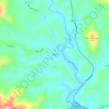
Name: Adial topographic map, elevation, terrain.

Location: Adial, Nelson County, Virginia, 22938, United States (37.84486 -78.85030 37.88486 -78.81030)

Average elevation: 221 m

Minimum elevation: 156 m

Maximum elevation: 464 m

Other topographic maps

Click on a map to view its topography, its elevation and its terrain.

Tye River

United States > Virginia > Nelson County

Average elevation: 251 m

Piney River

United States > Virginia > Nelson County

Average elevation: 266 m

Gear up for your next adventure:

💧Hydration Bladder - Hands-free hydration solution for long treks
🧢Hiking Hat - Sun-protective and breathable hats for long treks
🧴Insect Repellent - Protect yourself from bugs during outdoor adventures
💡Portable Camping Lamp - Rechargeable lamp for campsite lighting
🧥Waterproof Jacket - Lightweight rain jackets for hiking and outdoor activities

As an Amazon Associate, this site earns from qualifying purchases at no extra cost to you.