Geolocate

Pico los Raxos topographic map

Click on the map to display elevation.

About this map

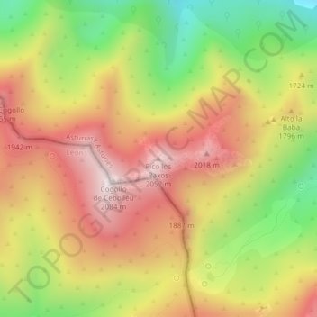
Name: Pico los Raxos topographic map, elevation, terrain.

Location: Pico los Raxos, Somiedo, Asturias, España (43.04798 -6.33279 43.04808 -6.33269)

Average elevation: 1,705 m

Minimum elevation: 1,278 m

Maximum elevation: 2,072 m

Other topographic maps

Click on a map to view its topography, its elevation and its terrain.

Valle de Lago

España > Asturias > Somiedo

Average elevation: 1,623 m

Parque Natural de Somiedo

España > Asturias > Somiedo

Average elevation: 1,299 m

Las Morteras

España > Asturias > Somiedo

Average elevation: 1,236 m

Laguna de Calabazosa

España > Asturias > Somiedo

Average elevation: 1,787 m

Clavillas

España > Asturias > Somiedo

Average elevation: 922 m

La Riera

España > Asturias > Somiedo

Average elevation: 839 m

Valle del Lago

España > Asturias > Somiedo

Average elevation: 1,623 m

Gear up for your next adventure:

🥾Trail Running Boots - Durable shoes designed for trail running
🎒Fully Waterproof Backpack - Total protection for photography gear and electronics
🏕️Camping Hammock - Integrated protection for sleeping between trees
🗺️Topographic Maps - Detailed maps to explore trails, mountains, and wilderness areas
🥾Approach Shoes - Shoes designed for climbing approaches and rugged trails

As an Amazon Associate, this site earns from qualifying purchases at no extra cost to you.