Geolocate

Maydena topographic map

Click on the map to display elevation.

About this map

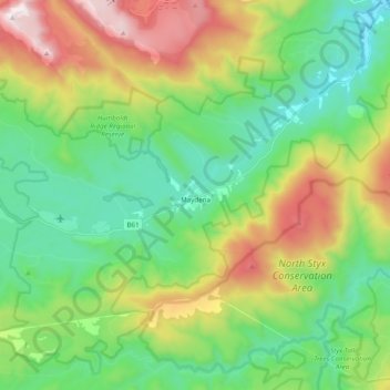
Name: Maydena topographic map, elevation, terrain.

Location: Maydena, Derwent Valley, Tasmania, 7140, Australia (-42.80295 146.45976 -42.70588 146.65526)

Average elevation: 546 m

Minimum elevation: 153 m

Maximum elevation: 1,361 m

Other topographic maps

Click on a map to view its topography, its elevation and its terrain.

Frog Hill

Australia > Tasmania

Average elevation: 875 m

Mount Kate

Australia > Tasmania

Average elevation: 995 m

Tasman Peninsula

Australia > Tasmania > Tasman > Fortescue

Average elevation: 167 m

Mount Jukes

Australia > Tasmania

Average elevation: 773 m

Ulverstone

Australia > Tasmania > Ulverstone

Average elevation: 37 m

Bullock Hill

Australia > Tasmania > Grove

Average elevation: 147 m

Highland Waters

Australia > Tasmania > London Lakes

Average elevation: 759 m

Stillwater Hill

Australia > Tasmania

Average elevation: 353 m

Legges Tor

Australia > Tasmania

Average elevation: 1,457 m

Rowlands Hill

Australia > Tasmania

Average elevation: 388 m

Recherche Bay

Australia > Tasmania

Average elevation: 10 m

Bastyan Dam

Australia > Tasmania > Tullah

Average elevation: 233 m

Gear up for your next adventure:

🧢Hiking Hat - Sun-protective and breathable hats for long treks
🦌Outdoor Trail Camera - Monitor wildlife activity near your favorite spots
Camping Essentials - All-in-one gear for a comfortable camping trip
🛌Down Sleeping Bag - Superior warmth-to-weight ratio for cold nights
🪜Heavy Duty Carabiners - Multi-use clips for securing gear to your backpack

As an Amazon Associate, this site earns from qualifying purchases at no extra cost to you.