
Lampeter topographic map
Interactive map
Click on the map to display elevation.
About this map
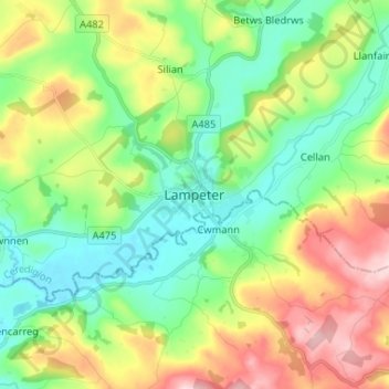
Name: Lampeter topographic map, elevation, terrain.
Location: Lampeter, Ceredigion, Pays de Galles, SA48 7DX, Royaume-Uni (52.07305 -4.11876 52.15305 -4.03876)
Average elevation: 197 m
Minimum elevation: 104 m
Maximum elevation: 367 m
Other topographic maps
Click on a map to view its topography, its elevation and its terrain.
Aberteifi / Cardigan
Royaume-Uni > Pays de Galles > Ceredigion
Aberteifi / Cardigan, Ceredigion, Pays de Galles, SA43 1JR, Royaume-Uni
Average elevation: 81 m