
Make a donation
Gear up for your next adventure:
As an Amazon Associate, this site earns from qualifying purchases at no extra cost to you.
Gainneville topographic map
Click on the map to display elevation.
Make a donation
Gear up for your next adventure:
As an Amazon Associate, this site earns from qualifying purchases at no extra cost to you.
About this map
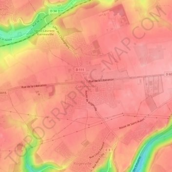
Name: Gainneville topographic map, elevation, terrain.
Average elevation: 89 m
Minimum elevation: 5 m
Maximum elevation: 111 m
Make a donation
Gear up for your next adventure:
As an Amazon Associate, this site earns from qualifying purchases at no extra cost to you.
Other topographic maps
Click on a map to view its topography, its elevation and its terrain.
Make a donation
Gear up for your next adventure:
As an Amazon Associate, this site earns from qualifying purchases at no extra cost to you.
Rouen
Frankrijk > Normandië > Seine-Maritime > Rouen
De hele museumcollectie is ondergebracht in het Hôtel d'Hocqueville, een statig stadskasteel uit het begin van de 18e eeuw. Het museum telt een duizendtal stukken aardewerk in het algemeen, van prehistorische potscherven via andere archeologische vondsten tot faiencewerk en porselein uit de 20e eeuw. Centraal…
Average elevation: 103 m