
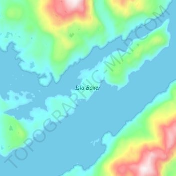
Isla Boxer topographic map
Interactive map
Click on the map to display elevation.
About this map
Name: Isla Boxer topographic map, elevation, terrain.
Average elevation: 187 m
Minimum elevation: -1 m
Maximum elevation: 1,169 m
Other topographic maps
Click on a map to view its topography, its elevation and its terrain.
Isla Byron
Chile > Región Aysén del General Carlos Ibáñez del Campo > Tortel
Isla Byron, Tortel, Provincia de Capitán Prat, Región Aysén del General Carlos Ibáñez del Campo, Chile
Average elevation: 15 m
Isla Javier
Chile > Región Aysén del General Carlos Ibáñez del Campo > Tortel
Isla Javier, Tortel, Provincia de Capitán Prat, Región Aysén del General Carlos Ibáñez del Campo, Chile
Average elevation: 107 m
Isla Juan Stuven
Chile > Región Aysén del General Carlos Ibáñez del Campo > Tortel
Isla Juan Stuven, Tortel, Provincia de Capitán Prat, Región Aysén del General Carlos Ibáñez del Campo, Chile
Average elevation: 76 m
Río Baker
Chile > Región Aysén del General Carlos Ibáñez del Campo > Tortel
Río Baker, Tortel, Provincia de Capitán Prat, Región Aysén del General Carlos Ibáñez del Campo, 61200000, Chile
Average elevation: 50 m
Isla Farquhar
Chile > Región Aysén del General Carlos Ibáñez del Campo > Tortel
Isla Farquhar, Tortel, Provincia de Capitán Prat, Región Aysén del General Carlos Ibáñez del Campo, Chile
Average elevation: 252 m