Geolocate

Carysbrook topographic map

Click on the map to display elevation.

About this map

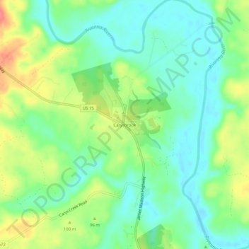
Name: Carysbrook topographic map, elevation, terrain.

Location: Carysbrook, Fluvanna County, Virginia, 23055, United States (37.79231 -78.26263 37.83231 -78.22263)

Average elevation: 84 m

Minimum elevation: 60 m

Maximum elevation: 127 m

Other topographic maps

Click on a map to view its topography, its elevation and its terrain.

Columbia

United States > Virginia > Fluvanna County

Average elevation: 78 m

Gear up for your next adventure:

🧢Outdoor Visor - Breathable visor for sunny hikes
🧭GPS Handheld Device - Reliable GPS navigation for outdoor adventures
🧶550 Survival Paracord - Versatile utility cord for emergency repairs and rigging
🔭Compact Binoculars - Lightweight optics for scouting trails and wildlife
Bushcraft Tarp - Versatile emergency shelter or gear protection

As an Amazon Associate, this site earns from qualifying purchases at no extra cost to you.