Geolocate

Saliceto topographic map

Click on the map to display elevation.

About this map

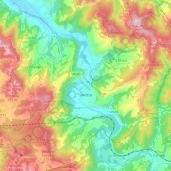
Name: Saliceto topographic map, elevation, terrain.

Location: Saliceto, Cuneo, Piedmont, 12079, Italy (44.38432 8.14764 44.44957 8.22090)

Average elevation: 549 m

Minimum elevation: 356 m

Maximum elevation: 804 m

Other topographic maps

Click on a map to view its topography, its elevation and its terrain.

Bertolini

Italy > Piedmont > Cuneo > Crissolo

Average elevation: 1,686 m

Montescotto

Italy > Piedmont > Cuneo > Barge

Average elevation: 643 m

Monastero

Italy > Piedmont > Cuneo > Mondovì

Average elevation: 448 m

Pievetta

Italy > Piedmont > Cuneo

Average elevation: 735 m

Pianche

Italy > Piedmont > Cuneo

Average elevation: 1,496 m

San Bernolfo

Italy > Piedmont > Cuneo > Vinadio

Average elevation: 2,036 m

Gear up for your next adventure:

🥾Approach Shoes - Shoes designed for climbing approaches and rugged trails
🧢Hiking Hat - Sun-protective and breathable hats for long treks
🥤Collapsible Travel Cup - Saves space and weight in your mess kit
🥾Approach Boots - Comfortable boots for hiking and climbing approaches
🔨Vehicle Emergency Tool - Safety tool for remote road trips to trailheads

As an Amazon Associate, this site earns from qualifying purchases at no extra cost to you.