Geolocate

Khonsa topographic map

Click on the map to display elevation.

Khonsa

Khonsa is located at 27°01′N 95°34′E / 27.02°N 95.57°E / 27.02; 95.57. It has an average elevation of 1215 metres (3986 feet).

Wikipedia (CC-BY-SA 3.0)

About this map

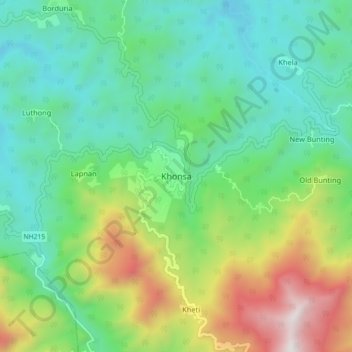
Name: Khonsa topographic map, elevation, terrain.

Location: Khonsa, Khonsa HQ, Tirap District, Arunachal Pradesh, 792130, India (26.95101 95.46611 27.03101 95.54611)

Average elevation: 858 m

Minimum elevation: 383 m

Maximum elevation: 1,996 m

Gear up for your next adventure:

🧰Multitool Knife - Compact and versatile tool for outdoor use
🔭Outdoor Binoculars - Lightweight binoculars for birdwatching and hiking
🎒Fully Waterproof Backpack - Total protection for photography gear and electronics
🧢Outdoor Cap - Protective cap for sun and rain during hikes
Lightweight Camping Tent - Portable shelter optimized for Canadian backcountry camping

As an Amazon Associate, this site earns from qualifying purchases at no extra cost to you.