
Make a donation
Gear up for your next adventure:
As an Amazon Associate, this site earns from qualifying purchases at no extra cost to you.
Trutnov topographic map
Click on the map to display elevation.
Make a donation
Gear up for your next adventure:
As an Amazon Associate, this site earns from qualifying purchases at no extra cost to you.
About this map
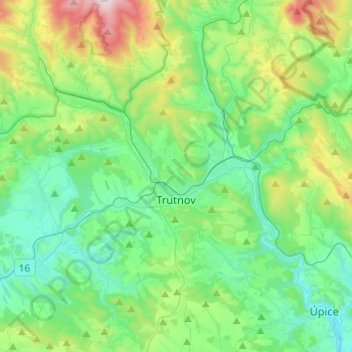
Name: Trutnov topographic map, elevation, terrain.
Average elevation: 501 m
Minimum elevation: 329 m
Maximum elevation: 1,030 m
Make a donation
Gear up for your next adventure:
As an Amazon Associate, this site earns from qualifying purchases at no extra cost to you.
Other topographic maps
Click on a map to view its topography, its elevation and its terrain.
Velká Deštná
Czechia > Northeast > Královéhradecký kraj > Deštné v Orlických horách
Velká Deštná (German: Deschneyer Großkoppe) is a mountain in the Hradec Králové Region of the Czech Republic. With an elevation of 1,116 m (3,661 ft), it is the highest mountain of the Orlické Mountains and of the whole Central Sudetes range. There is an observation tower on top of the mountain, which…
Average elevation: 962 m
Make a donation
Gear up for your next adventure:
As an Amazon Associate, this site earns from qualifying purchases at no extra cost to you.
Make a donation
Gear up for your next adventure:
As an Amazon Associate, this site earns from qualifying purchases at no extra cost to you.