
Ferlach topographic map
Click on the map to display elevation.
About this map
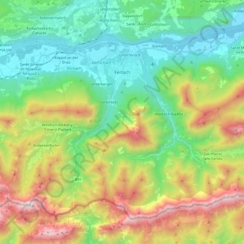
Name: Ferlach topographic map, elevation, terrain.
Location: Ferlach, Bezirk Klagenfurt-Land, Carinthia, 9170, Austria (46.43222 14.16298 46.55535 14.39550)
Average elevation: 991 m
Minimum elevation: 401 m
Maximum elevation: 2,150 m
Other topographic maps
Click on a map to view its topography, its elevation and its terrain.
Klagenfurt Land
Austria > Carinthia > Bezirk Klagenfurt-Land > Krumpendorf am Wörthersee
Average elevation: 894 m