Geolocate

Winkel topographic map

Click on the map to display elevation.

About this map

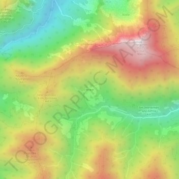
Name: Winkel topographic map, elevation, terrain.

Location: Winkel, Zell, Bezirk Klagenfurt-Land, Carinthia, 9170, Austria (46.45616 14.27779 46.49616 14.31779)

Average elevation: 1,142 m

Minimum elevation: 559 m

Maximum elevation: 1,817 m

Gear up for your next adventure:

🔭Compact Binoculars - Lightweight optics for scouting trails and wildlife
🧦Merino Wool Socks - Moisture-wicking comfort for long-distance hiking
🧢Sun Hat - Wide-brim hat for sun protection
🥾Hiking Shoes - Durable and comfortable shoes for trail hiking
🥾Hiking Gaiters - Protect legs and shoes from mud, snow, and debris

As an Amazon Associate, this site earns from qualifying purchases at no extra cost to you.