
Thank you for supporting this site ❤️
Make a donation
Make a donation
Gear up for your next adventure:
As an Amazon Associate, this site earns from qualifying purchases at no extra cost to you.
Corridon topographic map
Click on the map to display elevation.
Thank you for supporting this site ❤️
Make a donation
Make a donation
Gear up for your next adventure:
As an Amazon Associate, this site earns from qualifying purchases at no extra cost to you.
About this map
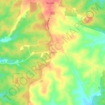
Name: Corridon topographic map, elevation, terrain.
Location: Corridon, Reynolds County, Missouri, 63666, United States (37.36199 -91.09235 37.40199 -91.05235)
Average elevation: 353 m
Minimum elevation: 315 m
Maximum elevation: 386 m
Thank you for supporting this site ❤️
Make a donation
Make a donation
Gear up for your next adventure:
As an Amazon Associate, this site earns from qualifying purchases at no extra cost to you.
Other topographic maps
Click on a map to view its topography, its elevation and its terrain.
Current River Conservation Area
United States > Missouri > Reynolds County > Ellington
Average elevation: 250 m