
Constance topographic map
Click on the map to display elevation.
About this map
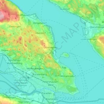
Name: Constance topographic map, elevation, terrain.
Average elevation: 420 m
Minimum elevation: 383 m
Maximum elevation: 577 m
Other topographic maps
Click on a map to view its topography, its elevation and its terrain.
Bleiche
Germany > Baden-Württemberg > Landkreis Konstanz > Stockach > Hindelwangen
Average elevation: 567 m
Alte Ölmühle
Germany > Baden-Württemberg > Landkreis Konstanz > Engen > Anselfingen
Average elevation: 561 m
Rickelshausen
Germany > Baden-Württemberg > Landkreis Konstanz > Radolfzell am Bodensee > Böhringen
Average elevation: 406 m