Geolocate

Larangan topographic map

Click on the map to display elevation.

About this map

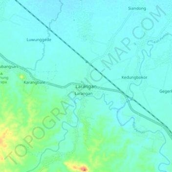
Name: Larangan topographic map, elevation, terrain.

Location: Larangan, Brebes, Central Java, Java, Indonesia (-7.04185 108.90835 -6.96185 108.98835)

Average elevation: 24 m

Minimum elevation: 11 m

Maximum elevation: 94 m

Gear up for your next adventure:

🧭GPS Tracker - Track your location in remote areas safely
🥾Hiking Gaiters - Protect legs and shoes from mud, snow, and debris
🧴Waterproofing Spray - Restore the DWR coating on jackets and tents
🧥Thermal Fleece Jacket - Versatile insulation for changing mountain temperatures
Camping Tent - Weather-resistant tents suitable for 2 to 6 people

As an Amazon Associate, this site earns from qualifying purchases at no extra cost to you.