Geolocate

Järvsö topographic map

Click on the map to display elevation.

About this map

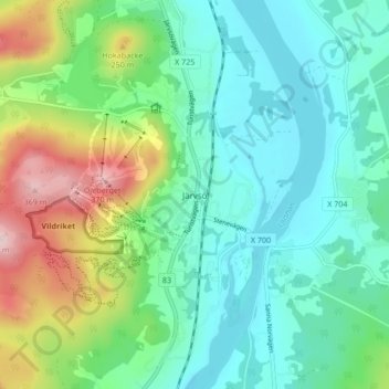
Name: Järvsö topographic map, elevation, terrain.

Location: Järvsö, Ljusdals kommun, Gävleborg County, 827 50, Sweden (61.69589 16.14932 61.73589 16.18932)

Average elevation: 180 m

Minimum elevation: 105 m

Maximum elevation: 377 m

Other topographic maps

Click on a map to view its topography, its elevation and its terrain.

Gävle

Sweden > Gävleborg County

Average elevation: 28 m

Bollnäs kommun

Sweden > Gävleborg County

Average elevation: 189 m

Hudiksvalls kommun

Sweden > Gävleborg County

Average elevation: 95 m

Gear up for your next adventure:

Camping Essentials - All-in-one gear for a comfortable camping trip
🥾Mountain Hiking Boots - High-traction boots for rocky terrain
🚲Heavy Duty Bike Lock - Secure your bike at the trailhead or during stops
🥾Hiking Shoes - Durable and comfortable shoes for trail hiking
🥾Mountain Hiking Shoes - Shoes with superior grip for mountainous terrain

As an Amazon Associate, this site earns from qualifying purchases at no extra cost to you.