
Make a donation
Gear up for your next adventure:
As an Amazon Associate, this site earns from qualifying purchases at no extra cost to you.
Ettersberg topographic map
Click on the map to display elevation.
Make a donation
Gear up for your next adventure:
As an Amazon Associate, this site earns from qualifying purchases at no extra cost to you.
About this map
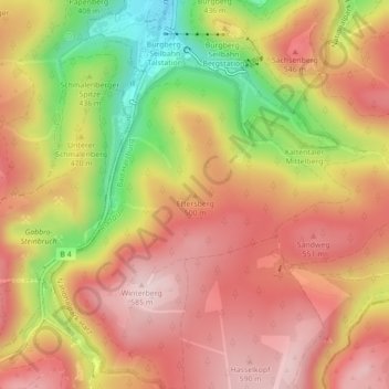
Name: Ettersberg topographic map, elevation, terrain.
Average elevation: 474 m
Minimum elevation: 285 m
Maximum elevation: 593 m
Make a donation
Gear up for your next adventure:
As an Amazon Associate, this site earns from qualifying purchases at no extra cost to you.
Other topographic maps
Click on a map to view its topography, its elevation and its terrain.
Bad Harzburg (Innenstadt)
Deutschland > Niedersachsen > Landkreis Goslar > Bad Harzburg
Die Stadt liegt im Bereich der nördlichen Ausläufer des Harzes auf einer Höhe zwischen 173 m ü. NHN (Feldmark bei Bettingerode) und 555 m ü. NHN über N.N. an der Landesgrenze von Niedersachsen und Sachsen-Anhalt. Sie erstreckt sich nach Süden in das Tal der Radau und grenzt an den Nationalpark Harz. Die…
Average elevation: 478 m