
Make a donation
Gear up for your next adventure:
As an Amazon Associate, this site earns from qualifying purchases at no extra cost to you.
Fluchthorn topographic map
Click on the map to display elevation.
Make a donation
Gear up for your next adventure:
As an Amazon Associate, this site earns from qualifying purchases at no extra cost to you.
Fluchthorn
Das österreichische Bundesamt für Eich- und Vermessungswesen bezeichnet die drei Gipfel als Nördliches Fluchthorn, Mittleres Fluchthorn und Südliches Fluchthorn, mit den Höhenangaben 3309 m, 3397 m und 3399 m.
Make a donation
Gear up for your next adventure:
As an Amazon Associate, this site earns from qualifying purchases at no extra cost to you.
About this map
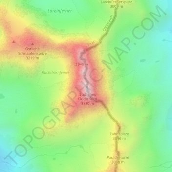
Name: Fluchthorn topographic map, elevation, terrain.
Location: Fluchthorn, Gemeinde Galtür, Bezirk Landeck, Tirol, Österreich (46.89137 10.22705 46.89147 10.22715)
Average elevation: 2,843 m
Minimum elevation: 2,476 m
Maximum elevation: 3,386 m
Make a donation
Gear up for your next adventure:
As an Amazon Associate, this site earns from qualifying purchases at no extra cost to you.