Geolocate

New Ross topographic map

Click on the map to display elevation.

About this map

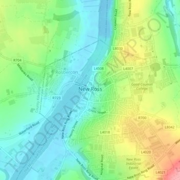
Name: New Ross topographic map, elevation, terrain.

Location: New Ross, County Wexford, Leinster, Ireland (52.38788 -6.95701 52.40294 -6.92830)

Average elevation: 39 m

Minimum elevation: -9 m

Maximum elevation: 115 m

Other topographic maps

Click on a map to view its topography, its elevation and its terrain.

Galbally

Ireland > County Wexford

Average elevation: 65 m

Old Ross

Ireland > County Wexford

Average elevation: 87 m

Inch

Ireland > County Wexford

Average elevation: 48 m

Oulart

Ireland > County Wexford

Average elevation: 98 m

Enniscorthy

Ireland > County Wexford > Enniscorthy

Average elevation: 44 m

Bann

Ireland > County Wexford

Average elevation: 52 m

Ramsgrange

Ireland > County Wexford > Ramsgrange

Average elevation: 51 m

Tara Hill

Ireland > County Wexford

Average elevation: 77 m

Gear up for your next adventure:

🥾Trail Hiking Socks - Comfortable socks to prevent blisters and fatigue
🥾Waterproof Hiking Boots - Essential footwear for rugged terrain and wet Canadian trails
🎒Hiking Backpack - Lightweight and ergonomic backpacks for day hikes or multi-day treks
🌡️Emergency Mylar Blankets - Compact thermal protection for unexpected nights outdoors
💡Compact LED Flashlight - Powerful and portable flashlight for outdoor use

As an Amazon Associate, this site earns from qualifying purchases at no extra cost to you.