Crewkerne topographic map
Interactive map
Click on the map to display elevation.
About this map
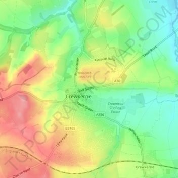
Name: Crewkerne topographic map, elevation, terrain.
Location: Crewkerne, South Somerset, Somerset, England, United Kingdom (50.87112 -2.81701 50.89947 -2.77439)
Average elevation: 82 m
Minimum elevation: 31 m
Maximum elevation: 141 m
Other topographic maps
Click on a map to view its topography, its elevation and its terrain.
Donyatt
United Kingdom > England > Somerset > South Somerset > Donyatt
Donyatt, South Somerset, Somerset, England, United Kingdom
Average elevation: 74 m
Broad River
United Kingdom > England > Somerset > South Somerset > West Chinnock
Broad River, West Chinnock, South Somerset, Somerset, South West England, England, TA18 7PL, United Kingdom
Average elevation: 61 m