Geolocate

Payali topographic map

Click on the map to display elevation.

About this map

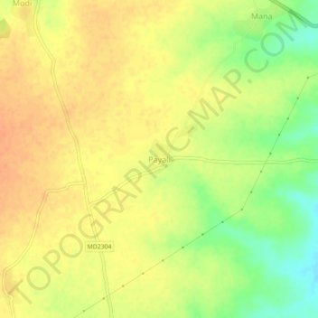
Name: Payali topographic map, elevation, terrain.

Location: Payali, Susner Tahsil, Agar Malwa, Madhya Pradesh, India (23.95614 76.20263 23.99614 76.24263)

Average elevation: 392 m

Minimum elevation: 366 m

Maximum elevation: 406 m

Other topographic maps

Click on a map to view its topography, its elevation and its terrain.

Susner

India > Madhya Pradesh > Susner Tahsil

Average elevation: 414 m

Mehatpur

India > Madhya Pradesh > Susner Tahsil

Average elevation: 390 m

Gear up for your next adventure:

🧥Softshell Hiking Jacket - The perfect balance of wind protection and breathability
🥾Trail Hiking Socks - Comfortable socks to prevent blisters and fatigue
🥾Hiking Shorts - Breathable shorts suitable for summer hikes
🏕️Camping Hammock - Integrated protection for sleeping between trees
🧥Waterproof Pants - Keep dry during rainy hiking conditions

As an Amazon Associate, this site earns from qualifying purchases at no extra cost to you.