
Make a donation
Gear up for your next adventure:
As an Amazon Associate, this site earns from qualifying purchases at no extra cost to you.
Écaussinnes topographic map
Click on the map to display elevation.
Make a donation
Gear up for your next adventure:
As an Amazon Associate, this site earns from qualifying purchases at no extra cost to you.
About this map
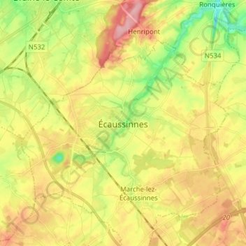
Name: Écaussinnes topographic map, elevation, terrain.
Location: Écaussinnes, Soignies, Hainaut, Wallonie, 7190, Belgique (50.52966 4.13537 50.60966 4.21537)
Average elevation: 109 m
Minimum elevation: 47 m
Maximum elevation: 170 m
Make a donation
Gear up for your next adventure:
As an Amazon Associate, this site earns from qualifying purchases at no extra cost to you.
Other topographic maps
Click on a map to view its topography, its elevation and its terrain.
Horrues
Belgique > Hainaut > Soignies > Soignies
La localité est un petit village de campagne. L'altitude varie entre 75 et 115 mètres. Bien que Horrues soit placé sur le plateau du Hainaut, le paysage est assez vallonné le long de la Senne. Le village est entouré de champs (betteraves, blé, maïs, pommes de terre, etc.)
Average elevation: 82 m