Geolocate

Brienno topographic map

Click on the map to display elevation.

About this map

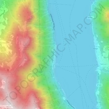
Name: Brienno topographic map, elevation, terrain.

Location: Brienno, Como, Lombardy, Italy (45.89484 9.10522 45.93513 9.14500)

Average elevation: 545 m

Minimum elevation: 188 m

Maximum elevation: 1,327 m

Gear up for your next adventure:

🔪Outdoor Multitool - Versatile tool for repairs and food prep in the wild
🧴Waterproofing Spray - Restore the DWR coating on jackets and tents
🐕Hiking Dog Pack - Let your canine companion carry their own water and food
🥾Waterproof Hiking Boots - Boots keeping your feet dry in wet conditions
🔋Lithium AA Batteries - Long-lasting power that performs in extreme cold

As an Amazon Associate, this site earns from qualifying purchases at no extra cost to you.