
Make a donation
Gear up for your next adventure:
As an Amazon Associate, this site earns from qualifying purchases at no extra cost to you.
Birkungen topographic map
Click on the map to display elevation.
Make a donation
Gear up for your next adventure:
As an Amazon Associate, this site earns from qualifying purchases at no extra cost to you.
Birkungen
Die erste urkundliche Erwähnung von Birkungen als Berkungen auch Berchungen fällt ins Jahr 1191. Ungefähr einen Kilometer südlich des Ortes, auf dem nördlichen Teil des Wingert genannten Höhenzuges, befindet sich die 1256 erstmals urkundlich erwähnte Burg Birkenstein. Der Bau einer Kirche fand um 1516 statt. Zwischen Leinefelde und Birkungen befand sich das Dorf Kirrode, heute eine Wüstung, es wurde um 1430 aufgegeben. Dicht bei der Ortslage befand sich auch das Kloster Rippenstein – belegt durch den Flurnamen Burg.
Make a donation
Gear up for your next adventure:
As an Amazon Associate, this site earns from qualifying purchases at no extra cost to you.
About this map
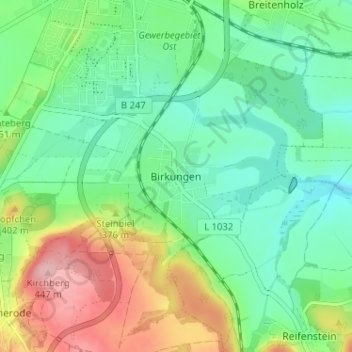
Name: Birkungen topographic map, elevation, terrain.
Average elevation: 351 m
Minimum elevation: 302 m
Maximum elevation: 451 m
Make a donation
Gear up for your next adventure:
As an Amazon Associate, this site earns from qualifying purchases at no extra cost to you.