Geolocate

Erpingham topographic map

Click on the map to display elevation.

About this map

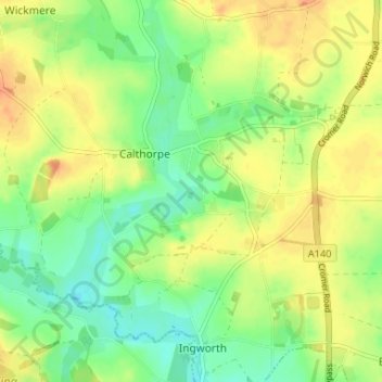
Name: Erpingham topographic map, elevation, terrain.

Location: Erpingham, North Norfolk, Norfolk, England, United Kingdom (52.81864 1.21683 52.85233 1.28225)

Average elevation: 28 m

Minimum elevation: 10 m

Maximum elevation: 46 m

Other topographic maps

Click on a map to view its topography, its elevation and its terrain.

Bradfield

United Kingdom > England > Norfolk > North Norfolk > Bradfield

Average elevation: 32 m

Gear up for your next adventure:

🛌Down Sleeping Bag - Superior warmth-to-weight ratio for cold nights
🧦Outdoor Socks - Durable socks designed for hiking and outdoor sports
Camping Groundsheet - Protect your tent from moisture and dirt
💧Collapsible Water Bottle - Space-saving water bottle for outdoor activities
🕯️Camping Lantern - Illuminates your entire campsite with high-efficiency LEDs

As an Amazon Associate, this site earns from qualifying purchases at no extra cost to you.