
Make a donation
Gear up for your next adventure:
As an Amazon Associate, this site earns from qualifying purchases at no extra cost to you.
Santa Maria topographic map
Click on the map to display elevation.
Make a donation
Gear up for your next adventure:
As an Amazon Associate, this site earns from qualifying purchases at no extra cost to you.
Santa Maria
In tegenstelling tot de omliggende eilanden bestaat Santa Maria voor slechts een klein deel uit graniet; vier vijfde van de bodem bestaat uit schist. Ook het zacht glooiende landschap verschilt van de andere La Maddalena-eilanden. De top van Santa Maria wordt gevormd door de 49 meter hoge Monte Guardia del Turco. Op het eiland zijn enkele private vakantiewoningen te vinden. Het eiland staat bekend om zijn stranden, zoals Cala Santa Maria en Cala di Fosso. Aan de oostkust van het eiland, bij Punta Filetto, staat een witte, uit 1913 stammende vuurtoren van 17 meter hoogte die de zeestraat tussen Santa Maria en Corcelli bewaakt.
Make a donation
Gear up for your next adventure:
As an Amazon Associate, this site earns from qualifying purchases at no extra cost to you.
About this map
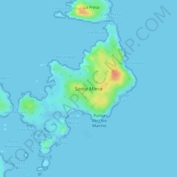
Name: Santa Maria topographic map, elevation, terrain.
Location: Santa Maria, La Maddalena, Nord-Est Sardegna, Sardinië, Italië (41.28744 9.36046 41.30816 9.38474)
Average elevation: 3 m
Minimum elevation: -2 m
Maximum elevation: 44 m
Make a donation
Gear up for your next adventure:
As an Amazon Associate, this site earns from qualifying purchases at no extra cost to you.