
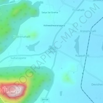
Nandi topographic map
Click on the map to display elevation.
About this map
Name: Nandi topographic map, elevation, terrain.
Average elevation: 988 m
Minimum elevation: 919 m
Maximum elevation: 1,471 m
Other topographic maps
Click on a map to view its topography, its elevation and its terrain.
Nandi Hills State Forest
India > Karnataka > Chikkaballapura taluk > Suddahalli
Average elevation: 865 m
Nandi Hills State Forest
India > Karnataka > Chikkaballapura taluk > Kanivenarayanapura
Average elevation: 853 m
Nandi Hills State Forest
India > Karnataka > Chikkaballapura taluk > Kanivenarayanapura
Average elevation: 853 m