
Sankt Goar topographic map
Click on the map to display elevation.
About this map
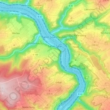
Name: Sankt Goar topographic map, elevation, terrain.
Average elevation: 232 m
Minimum elevation: 67 m
Maximum elevation: 423 m
Other topographic maps
Click on a map to view its topography, its elevation and its terrain.
Rhine Gorge
Germany > Rhineland-Palatinate > Rhein-Hunsrück-Kreis > Sankt Goar > Biebernheim
Average elevation: 177 m
Rhine Gorge
Germany > Rhineland-Palatinate > Rhein-Hunsrück-Kreis > Sankt Goar > Biebernheim
Average elevation: 177 m