
Uttar Bastar Kanker topographic map
Interactive map
Click on the map to display elevation.
About this map
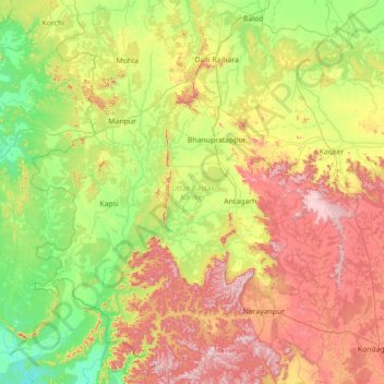
Name: Uttar Bastar Kanker topographic map, elevation, terrain.
Location: Uttar Bastar Kanker, Chhattisgarh, India (19.69837 80.40207 20.55881 81.81458)
Average elevation: 433 m
Minimum elevation: 204 m
Maximum elevation: 918 m
Other topographic maps
Click on a map to view its topography, its elevation and its terrain.
Gej
India > Chhattisgarh > Khadganva Tahsil
Gej, Khadganva Tahsil, Manendragarh-Chirimiri-Bharatpur District, Chhattisgarh, India
Average elevation: 508 m
Lath
India > Chhattisgarh > Sarangarh Tahsil
Lath, Sarangarh Tahsil, Raigarh District, Chhattisgarh, 496450, India
Average elevation: 259 m