Geolocate

Lakeside topographic map

Click on the map to display elevation.

About this map

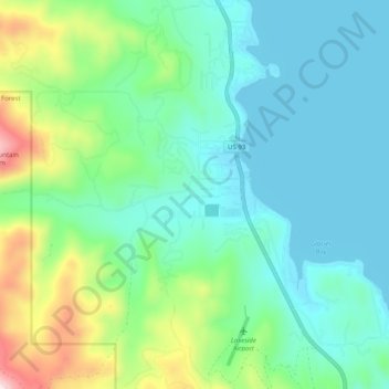
Name: Lakeside topographic map, elevation, terrain.

Location: Lakeside, Flathead County, Montana, 59922, United States (47.98336 -114.25572 48.05011 -114.18376)

Average elevation: 1,034 m

Minimum elevation: 879 m

Maximum elevation: 1,542 m

Gear up for your next adventure:

🧼Travel Hand Sanitizer - Keep hands clean when water is scarce
🌬️Windproof Camp Stove - Efficient cooking even on exposed mountain peaks
🧢Hiking Hat - Sun-protective and breathable hats for long treks
🔋Solar Power Bank - Keep your GPS and devices charged during long outdoor trips
🧳Compression Sacks - Maximize space in your backpack by shrinking gear

As an Amazon Associate, this site earns from qualifying purchases at no extra cost to you.