
Make a donation
Gear up for your next adventure:
As an Amazon Associate, this site earns from qualifying purchases at no extra cost to you.
Town of Cleveland topographic map
Click on the map to display elevation.
Make a donation
Gear up for your next adventure:
As an Amazon Associate, this site earns from qualifying purchases at no extra cost to you.
About this map
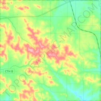
Name: Town of Cleveland topographic map, elevation, terrain.
Average elevation: 351 m
Minimum elevation: 306 m
Maximum elevation: 423 m
Make a donation
Gear up for your next adventure:
As an Amazon Associate, this site earns from qualifying purchases at no extra cost to you.
Other topographic maps
Click on a map to view its topography, its elevation and its terrain.
Black River Falls
United States > Wisconsin > Jackson County > Black River Falls
Average elevation: 264 m
York
United States > Wisconsin > Jackson County > Town of Northfield
York is in Jackson County, at latitude 44.5 and longitude −91.145 and at an elevation of 896 feet. It appears on the Pigeon Falls U.S Geological Survey Map and is in the Central Time Zone.
Average elevation: 296 m
Make a donation
Gear up for your next adventure:
As an Amazon Associate, this site earns from qualifying purchases at no extra cost to you.