Geolocate

Albano Vercellese topographic map

Click on the map to display elevation.

About this map
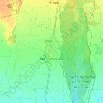
Name: Albano Vercellese topographic map, elevation, terrain.

Location: Albano Vercellese, Vercelli, Piemonte, 13030, Italia (45.40558 8.35358 45.45164 8.40653)

Average elevation: 152 m

Minimum elevation: 139 m

Maximum elevation: 170 m

Other topographic maps

Click on a map to view its topography, its elevation and its terrain.

Rolate

Italia > Piemonte > Vercelli > Varallo > Camasco

Average elevation: 933 m

Ferrera

Italia > Piemonte > Vercelli > Cravagliana

Average elevation: 1,019 m

Roasio Santa Maria

Italia > Piemonte > Vercelli

Average elevation: 294 m

Sant'Antonino

Italia > Piemonte > Vercelli > Saluggia

Average elevation: 188 m

Bocchetta delle Pisse

Italia > Piemonte > Vercelli > Alagna Valsesia

Average elevation: 2,235 m

Cesolo

Italia > Piemonte > Vercelli > Borgosesia

Average elevation: 457 m

Gear up for your next adventure:

🧢Outdoor Cap - Protective cap for sun and rain during hikes
🗺️Topographic Maps - Detailed maps to explore trails, mountains, and wilderness areas
🧊Portable Cooler - Keep food and drinks cold during outdoor adventures
🥘Camping Cookware Set - Compact nesting pots and pans for trail cooking
⛺Backpacking Tent - Lightweight tent for long-distance hiking trips

As an Amazon Associate, this site earns from qualifying purchases at no extra cost to you.