
Lac Barbel topographic map
Interactive map
Click on the map to display elevation.
About this map
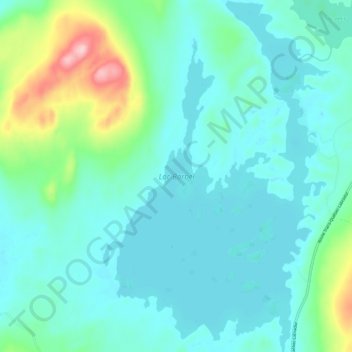
Name: Lac Barbel topographic map, elevation, terrain.
Average elevation: 564 m
Minimum elevation: 527 m
Maximum elevation: 728 m
Other topographic maps
Click on a map to view its topography, its elevation and its terrain.
Rivière Sainte-Marguerite
Canada > Québec > Rivière-Mouchalagane
Rivière Sainte-Marguerite, Rivière-Mouchalagane, Caniapiscau, Côte-Nord, Québec, Canada
Average elevation: 532 m
Mont Manic
Canada > Québec > Rivière-Mouchalagane
Mont Manic, Rivière-Mouchalagane, Caniapiscau, Côte-Nord, Québec, Canada
Average elevation: 591 m
Mont Jauffret
Canada > Québec > Rivière-Mouchalagane
Mont Jauffret, Rivière-Mouchalagane, Caniapiscau, Côte-Nord, Québec, Canada
Average elevation: 965 m