Geolocate

Benoy topographic map

Click on the map to display elevation.

About this map

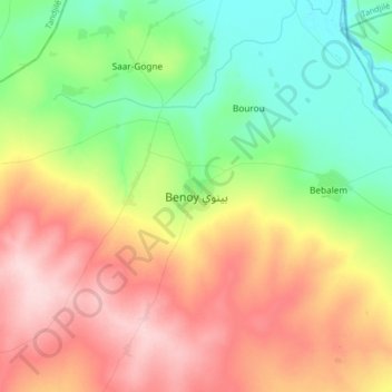
Name: Benoy topographic map, elevation, terrain.

Location: Benoy, Logone Occidental, Chad (8.82520 16.15844 9.14520 16.47844)

Average elevation: 439 m

Minimum elevation: 359 m

Maximum elevation: 551 m

Gear up for your next adventure:

🎒Fully Waterproof Backpack - Total protection for photography gear and electronics
🧦Outdoor Socks - Durable socks designed for hiking and outdoor sports
🥾Trail Running Boots - Durable shoes designed for trail running
🌬️Windproof Camp Stove - Efficient cooking even on exposed mountain peaks
🛶Kayak Dry Bag - Waterproof storage for kayaking adventures

As an Amazon Associate, this site earns from qualifying purchases at no extra cost to you.