Geolocate

Huapai topographic map

Click on the map to display elevation.

About this map
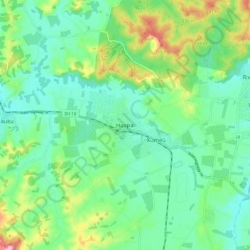
Name: Huapai topographic map, elevation, terrain.

Location: Huapai, Rodney, Auckland, 0810, New Zealand (-36.81205 174.50432 -36.73205 174.58432)

Average elevation: 51 m

Minimum elevation: 0 m

Maximum elevation: 183 m

Other topographic maps

Click on a map to view its topography, its elevation and its terrain.

Helensville

New Zealand > Auckland > Rodney

Average elevation: 21 m

Dome Forest

New Zealand > Auckland > Rodney

Average elevation: 168 m

Cowan Bay

New Zealand > Auckland > Rodney > Snells Beach

Average elevation: 22 m

Lake Rototoa

New Zealand > Auckland > Rodney

Average elevation: 102 m

Kawau Island

New Zealand > Auckland > Rodney

Average elevation: 26 m

Kawau Island

New Zealand > Auckland > Rodney

Average elevation: 26 m

Kawau Island

New Zealand > Auckland > Rodney

Average elevation: 26 m

Taupaki Estate

New Zealand > Auckland > Rodney > Kumeū

Average elevation: 37 m

Omaha Beach

New Zealand > Auckland > Rodney > Omaha

Average elevation: 3 m

Gear up for your next adventure:

🧴Sunscreen SPF - Broad-spectrum sunscreen for outdoor activities
🥾Mountain Hiking Shoes - Shoes with superior grip for mountainous terrain
🔦LED Headtorch - Bright and durable light for night activities
🥾Approach Boots - Comfortable boots for hiking and climbing approaches
⛺Bushcraft Tarp - Versatile emergency shelter or gear protection

As an Amazon Associate, this site earns from qualifying purchases at no extra cost to you.