Geolocate

Ayapel topographic map

Click on the map to display elevation.

About this map

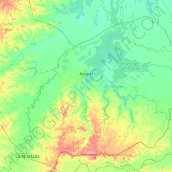
Name: Ayapel topographic map, elevation, terrain.

Location: Ayapel, San Jorge, Córdoba, Colombia (8.04924 -75.33994 8.49454 -74.78514)

Average elevation: 37 m

Minimum elevation: 11 m

Maximum elevation: 124 m

Other topographic maps

Click on a map to view its topography, its elevation and its terrain.

Tierra Santa

Colombia > Córdoba > Buenavista

Average elevation: 31 m

La Ye

Colombia > Córdoba > Sahagún

Average elevation: 122 m

Gear up for your next adventure:

Lightweight Backpacking Tent - Compact tent for efficient hiking trips
🥾Mountaineering Boots - Supportive boots for climbing and high-altitude hiking
Bushcraft Tarp - Versatile emergency shelter or gear protection
🥾Hiking Shoes - Durable and comfortable shoes for trail hiking
🥾Light Trekking Boots - Supportive boots for multi-day treks

As an Amazon Associate, this site earns from qualifying purchases at no extra cost to you.