
Make a donation
Gear up for your next adventure:
As an Amazon Associate, this site earns from qualifying purchases at no extra cost to you.
Sleidinge topographic map
Click on the map to display elevation.
Make a donation
Gear up for your next adventure:
As an Amazon Associate, this site earns from qualifying purchases at no extra cost to you.
Sleidinge
Sleidinge ligt in Zandig Vlaanderen op een hoogte van 5-9 meter. Er zijn kouterruggen met daartussen vanouds moerassige delen. Een belangrijke waterloop is het Sleidings Vaardeke. Verder bestaat het landschap uit veel weiden.
Make a donation
Gear up for your next adventure:
As an Amazon Associate, this site earns from qualifying purchases at no extra cost to you.
About this map
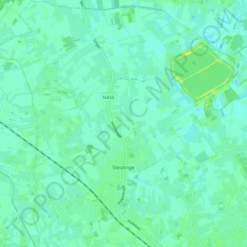
Name: Sleidinge topographic map, elevation, terrain.
Location: Sleidinge, Evergem, Gent, Oost-Vlaanderen, België (51.11388 3.63237 51.16990 3.72159)
Average elevation: 6 m
Minimum elevation: 1 m
Maximum elevation: 15 m
Make a donation
Gear up for your next adventure:
As an Amazon Associate, this site earns from qualifying purchases at no extra cost to you.
Other topographic maps
Click on a map to view its topography, its elevation and its terrain.
Langerbrugge
België > Oost-Vlaanderen > Gent > Evergem
Langerbrugge ligt aan het Kanaal Gent-Terneuzen en ter hoogte van Langerbrugge mondt ook de Ringvaart in dit kanaal uit. Deze loopt hier parallel aan de Nieuwe Kale.
Average elevation: 6 m
Langerbrugge
België > Oost-Vlaanderen > Gent > Evergem
Langerbrugge ligt aan het Kanaal Gent-Terneuzen en ter hoogte van Langerbrugge mondt ook de Ringvaart in dit kanaal uit. Deze loopt hier parallel aan de Nieuwe Kale.
Average elevation: 6 m
Make a donation
Gear up for your next adventure:
As an Amazon Associate, this site earns from qualifying purchases at no extra cost to you.