Geolocate

Pagdildilan topographic map

Click on the map to display elevation.

About this map
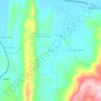
Name: Pagdildilan topographic map, elevation, terrain.

Location: Pagdildilan, San Juan, La Union, Ilocos Region, 2513, Philippines (16.62823 120.35134 16.66823 120.39134)

Average elevation: 90 m

Minimum elevation: 5 m

Maximum elevation: 320 m

Other topographic maps

Click on a map to view its topography, its elevation and its terrain.
Urbiztondo Beach

Philippines > La Union > San Juan

Average elevation: 13 m

Gear up for your next adventure:

⛺Camping Tent - Weather-resistant tents suitable for 2 to 6 people
🧰Multitool Knife - Compact and versatile tool for outdoor use
🛶Waterproof Dry Bags - Keep electronics and clothes dry during river crossings
👖Convertible Hiking Pants - Zip-off legs to adapt to changing weather conditions
🥘Camping Cookware Set - Compact nesting pots and pans for trail cooking

As an Amazon Associate, this site earns from qualifying purchases at no extra cost to you.