Geolocate

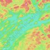
Sherborne Dam topographic map

Click on the map to display elevation.

About this map

Name: Sherborne Dam topographic map, elevation, terrain.

Location: Sherborne Dam, Algonquin Highlands, Haliburton County, Central Ontario, Ontario, Canada (45.17083 -78.81413 45.17103 -78.81376)

Average elevation: 373 m

Minimum elevation: 331 m

Maximum elevation: 421 m

Haliburton County trails, hiking, mountain biking, running and outdoor activities

Other topographic maps

Click on a map to view its topography, its elevation and its terrain.
Gear up for your next adventure:

🧤Rechargeable Heated Gloves - Extreme warmth for Canadian winter expeditions
🛶Kayak Accessories - Essential gear for safe and fun kayaking adventures
👟Trail Running Shoes - Agile footwear for fast-paced topographic exploration
🥽Outdoor Goggles - Protective eyewear for outdoor activities
🧤Insulated Winter Gloves - Heavy-duty protection for sub-zero Canadian adventures

As an Amazon Associate, this site earns from qualifying purchases at no extra cost to you.