
Make a donation
Gear up for your next adventure:
As an Amazon Associate, this site earns from qualifying purchases at no extra cost to you.
Casa Amarela topographic map
Click on the map to display elevation.
Make a donation
Gear up for your next adventure:
As an Amazon Associate, this site earns from qualifying purchases at no extra cost to you.
About this map
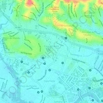
Name: Casa Amarela topographic map, elevation, terrain.
Average elevation: 20 m
Minimum elevation: 3 m
Maximum elevation: 73 m
Make a donation
Gear up for your next adventure:
As an Amazon Associate, this site earns from qualifying purchases at no extra cost to you.
Other topographic maps
Click on a map to view its topography, its elevation and its terrain.
Canal do Parnamirim
Brasil > Pernambuco > Região Metropolitana do Recife > Recife
Average elevation: 13 m
Make a donation
Gear up for your next adventure:
As an Amazon Associate, this site earns from qualifying purchases at no extra cost to you.
Praça da Periquita
Brasil > Pernambuco > Região Metropolitana do Recife > Recife
Average elevation: 49 m
Praia de Boa Viagem
Brasil > Pernambuco > Região Metropolitana do Recife > Recife
Average elevation: 5 m
Praça El Salvador
Brasil > Pernambuco > Região Metropolitana do Recife > Recife
Average elevation: 11 m
Make a donation
Gear up for your next adventure:
As an Amazon Associate, this site earns from qualifying purchases at no extra cost to you.
Praça do Entroncamento
Brasil > Pernambuco > Região Metropolitana do Recife > Recife
Average elevation: 10 m
Praça Ministro Salgado Filho
Brasil > Pernambuco > Região Metropolitana do Recife > Recife
Average elevation: 13 m
Academia da Cidade - Alto do Capitão
Brasil > Pernambuco > Região Metropolitana do Recife > Recife
Average elevation: 39 m
Praça São José dos Manguinhos
Brasil > Pernambuco > Região Metropolitana do Recife > Recife
Average elevation: 10 m
Make a donation
Gear up for your next adventure:
As an Amazon Associate, this site earns from qualifying purchases at no extra cost to you.
Lago da Praça da Vitória Régia
Brasil > Pernambuco > Região Metropolitana do Recife > Recife
Average elevation: 14 m
Praça João Pessoa de Queiroz
Brasil > Pernambuco > Região Metropolitana do Recife > Recife
Average elevation: 9 m
Praça do Internacional
Brasil > Pernambuco > Região Metropolitana do Recife > Recife
Average elevation: 8 m
Make a donation
Gear up for your next adventure:
As an Amazon Associate, this site earns from qualifying purchases at no extra cost to you.
Parque Treze de Maio
Brasil > Pernambuco > Região Metropolitana do Recife > Recife
Average elevation: 7 m