
Make a donation
Gear up for your next adventure:
As an Amazon Associate, this site earns from qualifying purchases at no extra cost to you.
Dylewska Góra topographic map
Click on the map to display elevation.
Make a donation
Gear up for your next adventure:
As an Amazon Associate, this site earns from qualifying purchases at no extra cost to you.
Dylewska Góra
Dylewska Góra (German: Kernsdorfer Höhe) is a hill located in northeastern Poland, south of the town of Ostróda, in the Warmian-Masurian Voivodeship. With elevation of 312 metres above sea level, it is one of the highest points of northern and central Poland. Dylewska Góra is a morainic hill, with its eastern and northern slopes covered by beech forest. On top there is a TV tower, as well as a 37-metre-high observation tower, which provides views of area up to 50 kilometres away.
Make a donation
Gear up for your next adventure:
As an Amazon Associate, this site earns from qualifying purchases at no extra cost to you.
About this map
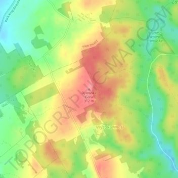
Name: Dylewska Góra topographic map, elevation, terrain.
Average elevation: 269 m
Minimum elevation: 227 m
Maximum elevation: 311 m
Make a donation
Gear up for your next adventure:
As an Amazon Associate, this site earns from qualifying purchases at no extra cost to you.