Geolocate

Indiana topographic map

Click on the map to display elevation.

About this map

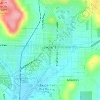
Name: Indiana topographic map, elevation, terrain.

Location: Indiana, Indiana County, Pennsylvania, United States (40.61250 -79.17403 40.63155 -79.13834)

Average elevation: 407 m

Minimum elevation: 375 m

Maximum elevation: 504 m

Gear up for your next adventure:

🧰Multitool Knife - Compact and versatile tool for outdoor use
🔋Solar Power Bank - Keep your GPS and devices charged during long outdoor trips
📷Outdoor Action Camera - Capture high-elevation views and rugged adventures
🥾Lightweight Hiking Boots - Boots for comfort and mobility on long hikes
🕯️Camping Lantern - Illuminates your entire campsite with high-efficiency LEDs

As an Amazon Associate, this site earns from qualifying purchases at no extra cost to you.