Geolocate

Sunnybank topographic map

Click on the map to display elevation.

About this map

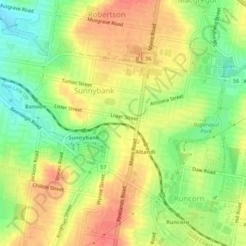
Name: Sunnybank topographic map, elevation, terrain.

Location: Sunnybank, Brisbane City, Queensland, 4109, Australia (-27.59076 153.03763 -27.56887 153.07605)

Average elevation: 54 m

Minimum elevation: 21 m

Maximum elevation: 83 m

Other topographic maps

Click on a map to view its topography, its elevation and its terrain.

Teneriffe

Australia > Queensland > Brisbane City

Average elevation: 11 m

Constitution Hill

Australia > Queensland > Brisbane City

Average elevation: 144 m

Gear up for your next adventure:

🥫Freeze-Dried Meals - Lightweight, high-calorie nutrition for multi-day treks
🧤Rechargeable Heated Gloves - Extreme warmth for Canadian winter expeditions
❄️Traction Ice Cleats - Slip-on spikes for icy trails and winter hiking
🔨Vehicle Emergency Tool - Safety tool for remote road trips to trailheads
🥤Collapsible Travel Cup - Saves space and weight in your mess kit

As an Amazon Associate, this site earns from qualifying purchases at no extra cost to you.