
Make a donation
Gear up for your next adventure:
As an Amazon Associate, this site earns from qualifying purchases at no extra cost to you.
Bad Rehburg topographic map
Click on the map to display elevation.
Make a donation
Gear up for your next adventure:
As an Amazon Associate, this site earns from qualifying purchases at no extra cost to you.
Bad Rehburg
Bad Rehburg ist ein ehemaliger Kurort in den Rehburger Bergen. Heute ist Bad Rehburg ein Ortsteil der Stadt Rehburg-Loccum im Süden des Landkreises Nienburg/Weser in Niedersachsen. Der Ort liegt auf einer Höhe von 85 m ü. NN und hat rund 700 Einwohner (Stand 2019).
Make a donation
Gear up for your next adventure:
As an Amazon Associate, this site earns from qualifying purchases at no extra cost to you.
About this map
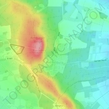
Name: Bad Rehburg topographic map, elevation, terrain.
Average elevation: 90 m
Minimum elevation: 49 m
Maximum elevation: 162 m
Make a donation
Gear up for your next adventure:
As an Amazon Associate, this site earns from qualifying purchases at no extra cost to you.
Other topographic maps
Click on a map to view its topography, its elevation and its terrain.
Pennigsehl
Deutschland > Niedersachsen > Landkreis Nienburg/Weser > Pennigsehl > Pennigsehl
Average elevation: 54 m
Make a donation
Gear up for your next adventure:
As an Amazon Associate, this site earns from qualifying purchases at no extra cost to you.
Make a donation
Gear up for your next adventure:
As an Amazon Associate, this site earns from qualifying purchases at no extra cost to you.
Make a donation
Gear up for your next adventure:
As an Amazon Associate, this site earns from qualifying purchases at no extra cost to you.
Haßberger Hauptgraben
Deutschland > Niedersachsen > Landkreis Nienburg/Weser > Gandesbergen
Average elevation: 22 m