Geolocate

Balzac topographic map

Click on the map to display elevation.

Balzac

Balzac occupies the interior of a wide bend of the Charente. The bedrock of the large eastern half of the commune, which is the highest in altitude, consists of limestone dating from the Upper Jurassic (Kimmeridgian) period.

Wikipedia (CC-BY-SA 3.0)

About this map

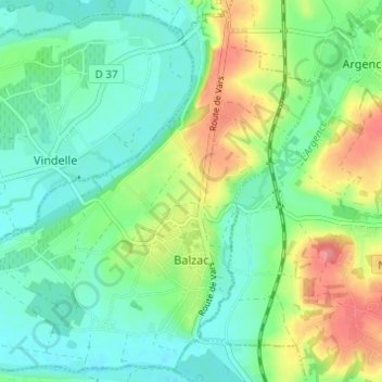
Name: Balzac topographic map, elevation, terrain.

Location: Balzac, Angoulême, Charente, Nouvelle-Aquitaine, Metropolitan France, 16430, France (45.69657 0.10145 45.73705 0.16270)

Average elevation: 55 m

Minimum elevation: 28 m

Maximum elevation: 112 m

Gear up for your next adventure:

💡Compact LED Flashlight - Powerful and portable flashlight for outdoor use
🧊Insulated Water Bottle - Keeps drinks cold in summer and prevents freezing in winter
🥾Hiking Shoes - Durable and comfortable shoes for trail hiking
🌡️Emergency Mylar Blankets - Compact thermal protection for unexpected nights outdoors
🧰Survival Kit - Essential gear for emergencies in the wilderness

As an Amazon Associate, this site earns from qualifying purchases at no extra cost to you.