
Florence topographic map
Click on the map to display elevation.
Florence
Florence is located in the coastal plain of South Carolina. It is in the northeastern part of the state and the northern part of Florence County. The average elevation above sea level is around 140 ft (43 m). Jeffries Creek is a tributary of the Great Pee Dee River and is the main waterway that flows through the city, passing south of the city center. According to the United States Census Bureau, the city has a total area of 23.49 square miles (60.8 km2), of which 23.39 square miles (60.6 km2) is land and 0.09 square miles (0.23 km2) (0.38%) is water.
About this map
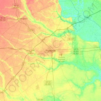
Name: Florence topographic map, elevation, terrain.
Average elevation: 35 m
Minimum elevation: 9 m
Maximum elevation: 62 m