
Mobile topographic map
Interactive map
Click on the map to display elevation.
About this map
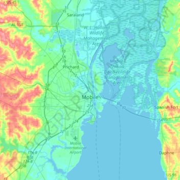
Name: Mobile topographic map, elevation, terrain.
Location: Mobile, Mobile County, Alabama, United States of America (30.56037 -88.22125 30.84346 -87.95662)
Average elevation: 14 m
Minimum elevation: -2 m
Maximum elevation: 76 m
Mobile is located in the southwestern corner of the U.S. state of Alabama. According to the United States Census Bureau, the city has a total area of 159.4 square miles (413 km2), with 117.9 square miles (305 km2) of it being land, and 41.5 square miles (107.5 km2), or 26.1% of the total, being covered by water. The elevation in Mobile ranges from 10 feet (3 m) on Water Street in downtown to 211 feet (64 m) at the Mobile Regional Airport.
Other topographic maps
Click on a map to view its topography, its elevation and its terrain.
Spanish River
United States of America > Alabama > Mobile
Spanish River, Mobile, Mobile County, Alabama, 36577, United States of America
Average elevation: 3 m