
Locronan topographic map
Click on the map to display elevation.
Locronan
La montagne de Locronan (Menez Lokorn en breton) avec ses 285 mètres d'altitude est l'un des points les plus élevés du massif des montagnes Noires qu'elle termine à l'ouest, même si géologiquement elle n'en fait pas partie. Locronan est située entre le plateau de Kerlaz à l'ouest s'abaissant de 130 à 60 m vers la baie de Douarnenez qu'il domine en falaises de l'anse du Ry à la pointe d'Ar Grabineg[1], et la haute saillie du Menez Lokorn à l'est, au pied duquel l'agglomération s'est développée[2].
About this map
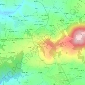
Name: Locronan topographic map, elevation, terrain.
Average elevation: 126 m
Minimum elevation: 34 m
Maximum elevation: 284 m
Other topographic maps
Click on a map to view its topography, its elevation and its terrain.
Roc’h Ruz
France > Bretagne > Finistère > Plounéour-Ménez
Les derniers relevés topographiques effectués par le service des Impôts de Morlaix, dans le cadre de la numérisation du cadastre, indiquent que le point culminant de la Bretagne est situé sur la commune de Plounéour-Ménez. Il s'agit de Roc'h Ruz qui culmine à 385 m d'altitude et est situé dans le…
Average elevation: 309 m
Tuchenn Kador
France > Bretagne > Finistère > Sizun
Le Ménez Kador, ou Tuchenn Kador, est le second point culminant de la partie bretonne du Massif armoricain dans les monts d'Arrée. Tout comme le Roc'h Trevezel, il atteint 385 mètres d'altitude.
Average elevation: 281 m