
Make a donation
Gear up for your next adventure:
As an Amazon Associate, this site earns from qualifying purchases at no extra cost to you.
Hudson topographic map
Click on the map to display elevation.
Make a donation
Gear up for your next adventure:
As an Amazon Associate, this site earns from qualifying purchases at no extra cost to you.
Hudson
Hudson features a predominantly flat and low-lying topography typical of the region, with an average elevation of approximately 16 feet above sea level. This terrain is interspersed with various wetlands and small lakes, creating a rich ecosystem that supports diverse wildlife. The area also includes a few gently rolling hills, but overall, the landscape is characterized by its proximity to the Gulf of Mexico, leading to sandy soils and coastal marshes. The nearby coastal environment contributes to the scenic beauty of Hudson, making it an appealing location for recreational activities like fishing and boating.
Make a donation
Gear up for your next adventure:
As an Amazon Associate, this site earns from qualifying purchases at no extra cost to you.
About this map
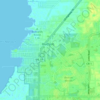
Name: Hudson topographic map, elevation, terrain.
Location: Hudson, Pasco County, Florida, 34667, United States (28.33816 -82.72364 28.37833 -82.65768)
Average elevation: 5 m
Minimum elevation: -1 m
Maximum elevation: 15 m
Make a donation
Gear up for your next adventure:
As an Amazon Associate, this site earns from qualifying purchases at no extra cost to you.